|
In the days when walking was the main
form of transport for the many, this path was one of two direct routes
used from Winsham to reach Chaffcombe and the villages and
hamlets beyond what is now the A30. (The other, mostly outside the parish, being from Winsham, via Hollowells, to
Lidmarsh using the A30 turnoff just below Cricket St Thomas).
The route is a short-cut across the
fields, missing out a stretch of road from Whatley to Kingston Well Lane
via Street.
Description of the Route
This path starts at a footpath sign on the B3162 just a few yards
beyond the Whatley Cross junction. Climb up the half-dozen or so
concrete block steps to the stile, then cross the field to the stile
opposite. Cross the track to the gate opposite.
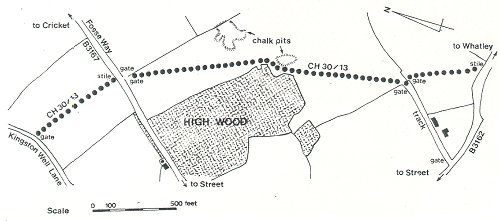
Cross the field in a
north-easterly direction, aiming for the large ash tree near the right
hand corner of High Wood. The path continues between this ash tree and the
wood, then diagonally across the field to the gate in the corner. Through
this and the next gate to the road (Fosse Way - B3167, NGR ST357075).
Cross the road to the stile then cross the field to the gate opposite and
into Kingston Well Lane.
| Definitive
Plan numbers |
CH30/13 |
|
|
|
|
| Nat. Grid start coordinates |
ST359069 |
|
|
|
|
| Nat. Grid end coordinates |
ST356077 |
|
|
|
|
| Approx length in metres |
820 |
|
|
|
|
|